A big, demanding day, climbing four munros in the Fannaich Range❤️

Introduction - the Fannaich's
The Fannaich's (or Fannich's) are a group of mountains that lie south east of Ullapool and north of Achnasheen. They are nestled between Loch Fannich, Loch Glascarnoch and Loch a'Bhraoin. There are nine munros in the range and they can be climbed together if you are supremely fit. Four was enough for me. With the exception of Fionn Bheinn, all the munros lie to the north of Loch Fannich.
The closest village for accommodation and food is Ullapool on the west coast. Ullapool was established in 1788 as a fishing village by the British Fisheries Society, specifically for catching herring. Thomas Telford actually designed the village and it hasn't changed much in over 200 years. Whereas the fisheries increased the size of Ullapool, it had existed as a community for hundreds of years before 1788 and immediately prior to Thomas Telford's involvement, comprised of around 20 dwellings.
Much older history of settlement is available. Brochs can be found at Dun Logie and Rhiroy on Lochside (a few miles south of Ullapool across Loch Broom), and about a mile north of the village is Dun Canna, an ancient fort system estimated to be around 2,500 years old. This large Iron Age fort is situated on a promontory at the foot of Ben More Coigach. It is an easy walk to visit the bay and from the fort there are beautiful views west to the Summer Isles. At low tide, it’s also possible to spot the Viking fish trap that was built in the 8th Century.
A road connecting Ullapool to the east coast was completed in the early 19th century. Today Ullapool is an important link to Scottish Islands with ferries travelling daily too and from the Stornoway on the Isle of Lewis in the Outer Hebrides.
On the journey from Ullapool to climb the Fannaich's you pass the famous Corrieshalloch Gorge. This is one of the most spectacular gorges in Scotland, and demonstrates how erosion resulting from the rapid melting of glaciers leads to the formation of deep gorges. There is a visitor centre, a café, ample parking and toilets.
Visitors can gaze 100m down at the crashing waterfalls of the River Droma from the site’s Victorian suspension bridge which was built by Sir John Fowler in 1873. Sir John went on to design the Forth Bridge and was heavily involved in designing the London Underground.
Onto the main event then, below you'll find my stats, the route, and information you will hopefully enjoy and find useful.
Stats and stuff - munros; maps & timings
Munro number: 48, 47, 46 & 45
Munro name(s): Beinn Liath Mhor Fannaich 954m (3129ft); Sgurr Mor 1110m (3641ft); Meall Gorm 949m (3113ft) & An Coileachan 923m (3028ft)
Area: Beinn Dearg & Loch Fannaich
Maps: Fannichs: Seana Bhraigh & Ben Wyvis (harveymaps.co.uk); OS Map of Beinn Dearg & Loch Fannich | Explorer 436 Map | Ordnance Survey Shop
Distance: 16.5 miles
Ascent: 1367m (4485ft)
Moving time: 6 hours 40 mins
Total time: 8 hours
Ratings
Fun 😍😍
Bogginess ☹️☹️☹️
Effort 😅😅😅
Navigation 🤔🤔🤔🤔
Local information
Eating: Home | Mysite (seafoodshack.co.uk); The Ceilidh Place - Ullapool Rooms, Restaurant, Cafe & Bookshop; Restaurant - The Seaforth
There are loads of places to eat in Ullapool but having sampled the wares from these three I know for sure I can recommend them.
Accommodation: The Ceilidh Place - Ullapool Rooms, Restaurant, Cafe & Bookshop - you need to contact the Ceilidh Place directly to book both rooms and the bunkhouse.
Home | millviewbnbullapool - contact direct to book, brilliant B&B.
There is a lot of accommodation in Ullapool. Most is represented on Booking.com. I have stayed at the above facilities, neither of which are on Booking.com but I would definitely stay again.
Facilities: Tesco; Petrol; climbing shop; various galleries; museum and many more! Visit this site for lots of information Welcome to Ullapool - Accommodation Highlands of Scotland
Don't miss: Corrieshalloch Gorge | National Trust for Scotland (nts.org.uk)
The route
I stayed at the bunkhouse owned by the Ceilidh Place called the Clubhouse. It sits across the road about 50m from the Ceilidh Place and has lots of parking. It has basic bunk bedded rooms for one, two, three or four persons. It can accommodate 32 across 11 rooms. The cost for a room with 2 beds and a sink for two nights was £80, I assume a single room wasn't available. To be honest it was a bit tired and there are no drying facilities; however, it was clean, cosy and free from midges!

Given I was staying only a 20 minute drive to the start of my days walking, I had a leisurely start and a good full Scottish breakfast. You can buy breakfast in the Ceilidh Place from 8.00am to 11.00am, and very good it is too!
The start of the walk is on the A835 a few miles past the Braemore Junction on the way to Inverness. About 1km past the east end of Loch Droma there is a marked parking place at a bridge across the Abhainn a Ghiubhais Li. Around 200m beyond this first parking, there is another smaller area at the entrance to the forestry track. There is space for about 4 cars without blocking access.
The route involves a 3km walk to a bridge across the Abhainn a Ghiubhais Li (NH264721). There are two ways to this point. I had decided to take the land rover track through the forest to the bridge as opposed to the rough path along the river. The path along the river involves an extra river crossing that can be difficult when in spate. The forest track is slightly longer but much easier. The views north towards Beinn Dearg and Cona Mheall were breath-taking.

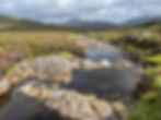
The bridge over the Abhainn a Ghiubhais Li is at 331m. I must say the river looks like an excellent "dipping" river, but maybe not today.
After crossing the bridge the track continues skirting the base of Creag Dubh Fannich towards Loch Li. At some point you need to strike uphill. There is a faint path straight up from the bridge, a slightly better trodden path leaves the main track after around 1km after the bridge. Being slightly bloody minded I decided to make my own way up the slope, the most direct way. It was steep in places but short tussocky grasses made for a fairly easy ascent.

Once atop Creag Dubh Fannich, the route to the summit of Beinn Liath Mhor Fannaich was clear. Having said that, if you encounter limited visibility, navigation in these mountains is complex. The ridge snakes in all directions with steep cliffs and beckoning corries awaiting the unprepared.
Beinn Liath Mhor Fannaich has a long flat top which narrows to a ridge dropping to 845m. Once the col has been reached the steep slog up onto Sgurr Mor begins.
Once again great care is required as the headwall of Coireag Barr an Fhialaidh falls almost vertically to the east of the summit of Sgurr Mor.


After the summit of Sgurr Mor the route swings to the south east, the distances
between the tops increases and the ridges become wider.


The geology here is fascinating. Look at the horizontal parallel ridges towards the summit of Meall Gorm. For the geology geeks amongst us, these are quaternary landforms called solifluction terraces, which are formed through the slow downslope movement of weathered material on mountains. These are some of the best examples of solifluction terraces in Britain. They are up to 5m wide, 0.7m high and still active. I've added a geological map to the photo album for this post for those interested.

The Fannaichs are a Site of Special Scientific Interest (SSSI) because they contain geological and biological features of national importance. I photographed the nationally scarce alpine bearberry near the summit of Sgurr Mor. It's not a great picture but proof it's still fighting and maintaining it's habitat in the high mountains. For more information this Site Management Statement from Scottish Natural Heritage is worth a read.
The wide and gentle ridge made for an easy ascent to the summit of Meall Gorm, and the easy walking continued towards An Coileachan.


Now the bog rating comes into it's own! The descent into the corrie down to Loch nan Eun was refreshingly simple, but there followed 3km of bog trotting, particularly exhausting after such a big day. There is no path to speak of and you just have to navigate as best you can between peat haggs and deep bog. It nearly broke me and I can admit to tears and a serious sense of humour failing. The relief of reaching the path at a bridge over the Abhainn a Ghiubhais Li (NH253712) was incredible.
The route was now straightforward, follow the path back to the first bridge and retrace your steps along the land rover track to the start point. You have to climb a bit up through the woods, but I still maintain that this minor inconvenience outweighs the serious tears that would have been shed following the river and more bog navigation.
Claire's top tip....
Know your bog....
Honestly, years of learning "bog" has paid off.
There are so many types of bog waiting to get you. Up to a quarter of Scotland is covered by bog. If you compare that statistic to the fact that 91% of Scotland’s population lives on 2.3% of Scotland’s total land area, it's very likely you will encounter a bog.
There are four main natural bog types in Scotland; blanket bog, raised bog, fens and bog woodland. Blanket bog makes up 23% of Scotland's bogs and covers much of the north-west highlands. Rare globally, Scotland holds a significant proportion of the European and world resource of blanket bog. Blanket bogs go hand in hand with peat. Dead remains of the sphagnum mosses pile up and get pressed together to eventually form the soil we know as peat. Peat forms at a very slow rate – 1mm per year or 1 metre per millennium. Peat builds up at different rates to form patterns of hummocks and hollows.
Bog trotting is a very definite skill. Not only negotiating the hummocks and hollows of peat, but also recognising the sphagnum moss filled, full sized body traps. Knowing what is safe to stand on, and what will consign you to a watery hell. Then there are the surprisingly firm footfalls that initially look like disaster, but allow you to breath again when you don't sink.
Blanket bogs are made up of a variety of species:
Heather, both bog heather or crossleaf heath (Erica tetralix) and ling heather (Calluna vulgaris);
Bog cotton, both common (Eriophorum angustifolium) and hare's-tail (Eriophorum vaginatum)
Deer grass (Trichophorum germanicum)
Round leaved sun dew (Drosera rotundifolia)
Sphagnum mosses - numerous variants approximately 380 in the UK
The rules of crossing a bog are pretty simple, avoid sphagnum moss and bog cotton, they tend to grow on very wet areas and you will disappear! Deer grass is a fairly good bet to have a solid root so can be used as a stepping "stone". Bare peat haggs (hollows) are mixed, some are incredibly firm and others sneakily stodgy.
Just take care, look ahead and don't lose your sense of humour!
Coming next......
Knoydart again......so soon!
Thank you for reading ❤️ xx
Related Posts


Amazing stuff Claire and what an effort traversing those bogs! You’re a wonderful writer. Thanks for sharing your experience. 😊
Darryl
I'm so proud of you love. 💖xxx
Another great account of your mountain hike! My Dad taught me "bog trotting" at a very young age, I just didn't know that's what it was called! 🤣. Fantastic.
Thank you for your excellent photos. You picked a sunny day with clear views - not many are so lucky. A significant distance 16 miles with 4 Munros. Loved the geology reference and the rare alpine in full bloom.